|
|
Post Reply 
|
Page 12> |
| Author |
 Printable Version Printable Version Google Google Delicious Delicious Digg Digg StumbleUpon StumbleUpon Windows Live Windows Live Yahoo Bookmarks Yahoo Bookmarks reddit reddit Facebook Facebook MySpace MySpace Newsvine Newsvine Furl Furl Topic Search Topic Search  Topic Options Topic Options
|
|
ronahue 
Senior Member 
Joined: 02 Jun 2015 Location: Massachusetts Online Status: Offline Posts: 316 |
 Topic: Towing steep inclines, brake fade, proper braking Topic: Towing steep inclines, brake fade, proper brakingPosted: 24 Sep 2016 at 4:43pm |
|
|
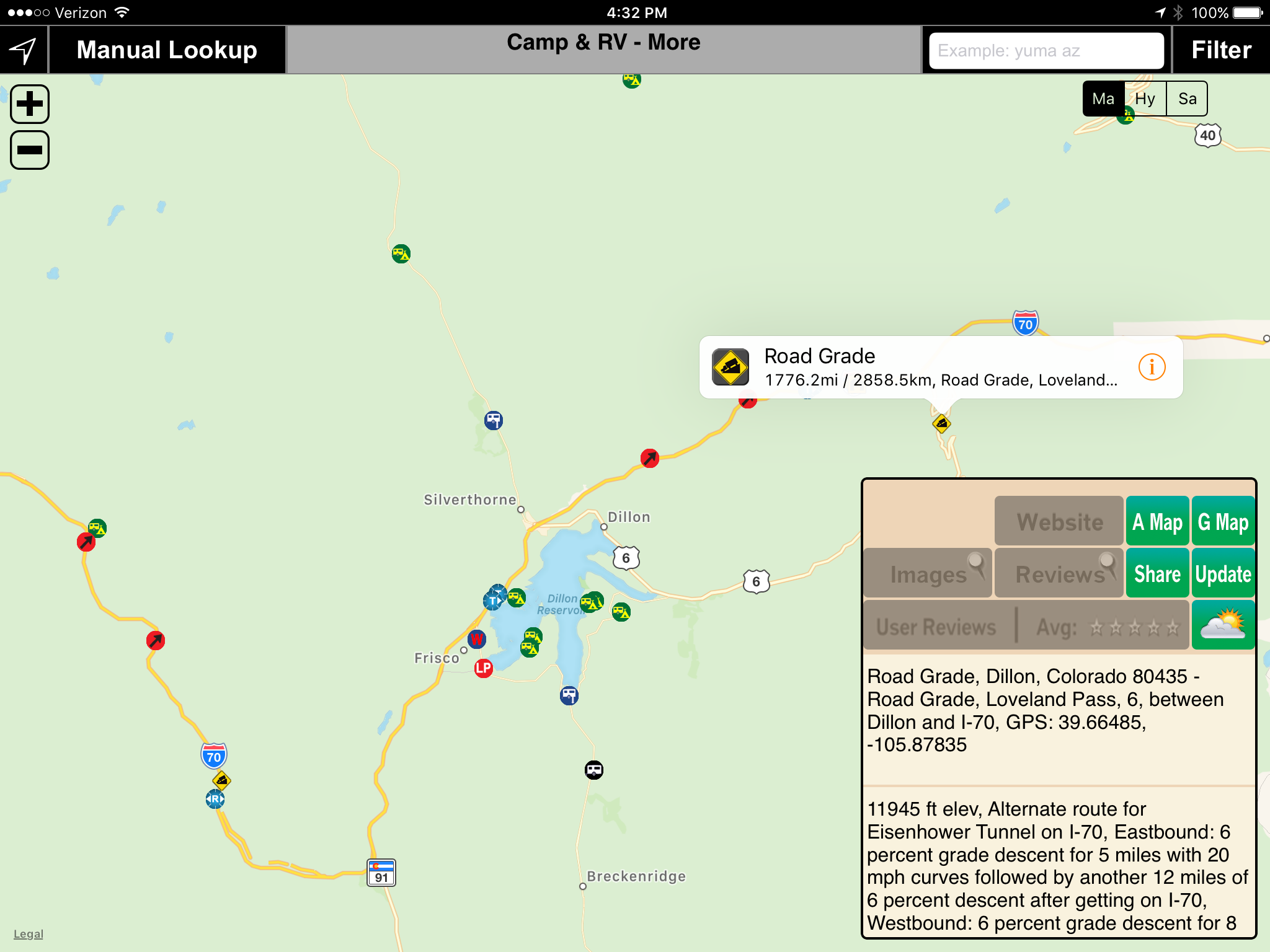
While it will not show a route Allstays app will provide excellent information on grades.
 |
||
|
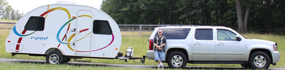
Ron & Sharon
2015 R-Pod 179 2022 Nissan Frontier No trees were harmed in the sending of this message but a billion electrons were really agitated |
||
 |
||
|
sean p
Groupie 
Joined: 24 Feb 2016 Location: athens ga Online Status: Offline Posts: 48 |
Posted: 24 Sep 2016 at 6:20am |
|
|
I'm on that stretch of 70 in the rockies all the time.the down grades are only 5-7%. but still steep and needeing some braking.
|
||
|
2016 179pod--BETTY
2010 nissan frontier Sean and Doug Butchie the morkie touring the west |
||
|
||
|
Rustler
Senior Member

Joined: 07 May 2016 Location: S. Oregon Coast Online Status: Offline Posts: 100 |
Posted: 23 Sep 2016 at 11:02pm |
|
Yeah, Google Earth elevation profile is a work in progress. I suspect the very short sections of excessive grade (the little wiggles) are due to errors in the ground elevation at different points along the route. Yes, maybe it has to do with the road cuts and fills. When I run a route from Coos Bay, Oregon to Mount Shasta City, California, it doesn't show any obviously erroneous grades. So the results will of course vary with the particulars. But it is kinda fun to play with. I've noticed another strange thing. Sometimes the close up view of a bridge shows the roadway surface of the bridge laying on the river-bed below. Yes, a work in progress.
|
||
|
Russ
2009 Toyota RAV4 V6 w/ tow package 2016 Rpod 171 HRE |
||
|
||
|
CharlieM
Senior Member
Joined: 23 Nov 2012 Location: N. Colorado Online Status: Offline Posts: 1797 |
Posted: 23 Sep 2016 at 10:43pm |
|
Russ, You broke the code on Eisenhower tunnel. I see that now. However, try the Lee Vining, CA to Yosemite National Park route. This traverses Tioga Pass to the park entrance. GE shows the max slope as 25%. There is a little wiggle in the plot that does show 25%, but I've climbed that road and the max incline in that area is 9%. No tunnels, but there may be some fill. I guess you take Google Earth with a grain of salt, or a big chunk of rock  , but it is fun to play with it. Thanks for the tip. , but it is fun to play with it. Thanks for the tip. |
||
|
Charlie
Northern Colorado OLD: 2013 RP-172, 2010 Honda Pilot 3.5L 4WD PRESENT: 2014 Camplite 21RBS, 2013 Supercharged Tacoma 4L V6 4WD |
||
|
||
|
Rustler
Senior Member
Joined: 07 May 2016 Location: S. Oregon Coast Online Status: Offline Posts: 100 |
Posted: 23 Sep 2016 at 10:00pm |
|
I tried the same route and also noticed some very strange (steep) grades. But when I zoomed in on the area with these anomalies, it is in the location of the Eisenhower Tunnel. Evidently Google Earth is using ground elevation (the mountain above the tunnel) to calculate the road profile. So I would just ignore the results for the portion of the route in the tunnel. Using Google Earth you can easily determine ground elevation and geographic coordinates - just point the cursor at the location of interest. There isn't a tremendous elevation difference between both ends of the tunnel. The ends are at 11,186 feet and 11,075 feet, just a 100 feet difference. Using the "Tools - Ruler" utility the straight-line distance between tunnel entrances is 1.72 miles. So the average grade in the tunnel is not severe. So you didn't do anything wrong, Charlie. Google Earth doesn't deal with tunnels correctly. Maybe they will get the problem fixed in the future. In the meantime we'll just ignore grades shown in tunnels. |
||
|
Russ
2009 Toyota RAV4 V6 w/ tow package 2016 Rpod 171 HRE |
||
|
||
|
techntrek
Admin Group - pHp 
Joined: 29 Jul 2009 Location: MD Online Status: Offline Posts: 9059 |
Posted: 23 Sep 2016 at 8:25pm |
|
|
You can only take that route with a helipod.
|
||
|
||
|
CharlieM
Senior Member
Joined: 23 Nov 2012 Location: N. Colorado Online Status: Offline Posts: 1797 |
Posted: 23 Sep 2016 at 4:36pm |
|
I must be doing something wrong. I tried Google Earth going from Denver to Vail, CO. The elevation profile showed grades of +34% to -50% along the route. No way! |
||
|
Charlie
Northern Colorado OLD: 2013 RP-172, 2010 Honda Pilot 3.5L 4WD PRESENT: 2014 Camplite 21RBS, 2013 Supercharged Tacoma 4L V6 4WD |
||
|
||
|
techntrek
Admin Group - pHp
Joined: 29 Jul 2009 Location: MD Online Status: Offline Posts: 9059 |
Posted: 23 Sep 2016 at 3:36pm |
|
|
Rustler, I actually remember the left-side emergency truck ramp on that pass because it is so unusual to have one on the left. We went through there this summer. One of the links at the top, I don't remember which pass, has video of a truck taking a left-side ramp (wrecking his truck in the process).
I wish Google Maps had that same feature. With our pod I rarely needed brakes on downhills except on the steepest hills, auto-downshifting and advanced engine braking (fuel cut, valves closed) did most of the work. With our current rig I need to apply brakes on most hills.
|
||
|
||
|
StephenH
podders Helping podders - pHp

Joined: 29 Nov 2015 Location: Wake Forest, NC Online Status: Offline Posts: 6288 |
Posted: 23 Sep 2016 at 10:08am |
|
|
On our most recent trip, we had some pretty steep up and down grades. We tow our RP-179 with a Ford Escape. On the downhill slopes, the transmission will downshift automatically to help keep us from speeding up too much. Even so, on some of the down slopes, I had to use the brakes also. I'm really glad that the R-Pod's electric brakes work so well.
|
||
|
StephenH
Happy is the man that findeth wisdom,... ouR escaPOD mods Former RPod 179 Current Cherokee Grey Wolf 24 JS |
||
|
||
|
Leo B
podders Helping podders - pHp
Joined: 13 Jan 2012 Location: Lyndonville, VT Online Status: Offline Posts: 4508 |
Posted: 23 Sep 2016 at 6:19am |
|
|
Interesting points!
|
||
|
Leo & Melissa Bachand
2017 Ford F150 2021 Vista Cruiser 19 csk Previously owned 2015 Rpod 179 2010 Rpod 171 |
||
|
||
|
Post Reply
|
Page 12> |
| Forum Jump | Forum Permissions You cannot post new topics in this forum You cannot reply to topics in this forum You cannot delete your posts in this forum You cannot edit your posts in this forum You cannot create polls in this forum You cannot vote in polls in this forum |


 Towing steep inclines, brake fade, proper braking